Introduction
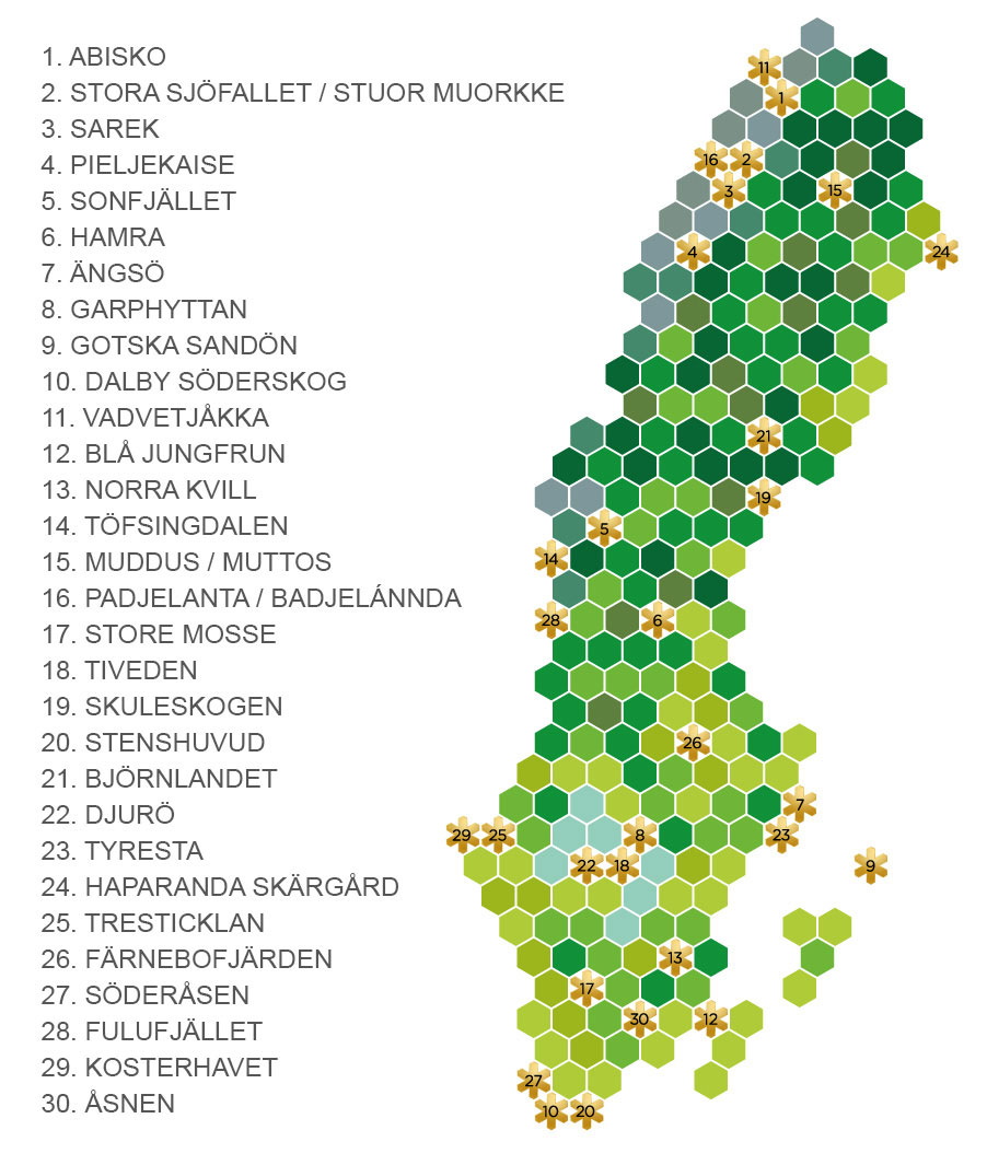
The company will send me for a firefighting course. I chose to take the course end of May
When I finish my course in Gothenburg I will drive to Öland for a few days of bird watching before driving to Skåne for more bird watching. End of May and I will drive back to Gothenburg and the firefighting course on Öckerö in the archipelago and I hope to be able to see some exciting bird life there.
My Guide
Well, I booked my Guide 2 months in advance. He should call me at 10 o'clock in the morning. No call from the tw*t and I was angry. I had broken my birding in the morning to get back here for his call. It was almost 11 thirty when he called and I was in my car and I never replied.
I save 1000 US Dollars and I really hope he had counted to get this money and spent it already. On something expensive that he could not afford and with no means to get the EXTRA 1000 US. Well, you really don´t need any Guide when on Öland. Follow Visit Öland´s web page - The top 20 birding sites on Öland and you have everything you need.
• SVALGÅRDEN - WE OFFER ACCOMODATION AND BIRDGUIDING N KVINSGRÖTA, Öland!
• Segerstad's lighthouse - Welcome to the best birdwatching accomodation on Öland!
Land transportation
• Rented car
I have rented a Volvo from HERZ
Accommodations
Hotel Skansen in Färjestaden, Öland: 11 May to 17 May 2019

Weather / climate
Sweden in April and May, could be summer and it can be winter, or anything in between. In the South I hope to have sunshine and the summer in good progress. And I might be lucky Skåne and Öland and I can walk around in shorts and shirt. But it can as well be winter and I need to pack a lot of clothes this time.
And coming to Skåne and Öland I might be lucky and I can walk around in shorts and shirt. But it can as well be winter and I need to pack a lot of clothes this time.
Weather in the spring
Visiting in the spring time and you really need to pack a huge bag. In the morning it is below zero so I have packed full winter equipment, parka jacket, warm hat and gloves. And of course warm socks. In the late morning you will have to change the winter clothing to “spring” clothing, a wind breaker.
If it is sunshine the temperature is easily reaching 20°C at lunch time and that can easily be almost 30°C. If you have a car it is no problem, just keep everything in the car and change as the day proceeds and you ae ready for any weather changes you will run in to.

South of Sweden - Climate & Temperature
Pictures from www.climatemps.com

South of Sweden - Climate & Temperature - Click picture for full size picture
Pictures from www.climatemps.com
Equipment
Canon 5D Mk. III and Canon 5D Mk. IV
Canon EF 28-300/3,5-5,6 L IS USM
Canon EF 70-200/2,8L IS II USM
Canon EF 100-400mm f/4.5-5.6L IS II USM lens
Canon Speedlite 600EXII-RT flash
Canon PowerShot G7X Mark II
Panasonic HC-W585 video camera
Sound recorder
ZOOM H5 Handy Recorder
References/Resources
www.natursidan.se Excellent page, but in Swedish only
Visit the Swedish Environmental Protection Agency and choose between Swedish and English
Naturum - visitor centres in nature - A naturum is a visitor centre with activities and exhibitions, located at several of
 Sweden’s national parks and nature reserves. Here, you will be welcomed by friendly, knowledgeable staff who will answer your questions and guide you through the area’s sights of interest.
List of Swedish National Parks (With information about every park in English) from the Swedish Environmental Protection Agency, click HERE .
Visit Öland - The top 20 birding sites on Öland with maps and information - Excellent page!
ebird - Find birding hotspots with bird checklists from all over the world
Avibase - is an extensive database information system about all birds of the world, containing over 25 million records about 10,000 species and 22,000 subspecies of birds, including distribution information for 12,000 regions, taxonomy, synonyms in several languages
Cloudbirders - Read birding trip reports from all over the world
Fatbirder - Linking birders worldwide... Wildlife Travellers see their sister site: WAND

Fatbirder is a fantastic web page with information from, I think every country in the world. My first stop when I plan for my bird watching trips. There is information about locations and guides, well, pretty much everything you need to know. Sometimes this is the only place I need to visit to plan my trip.
BirdingPal - find a birding Guide around the world


And the web page you cannot live without. I have been around the world looking for birds. I usually have a Guide, but sometimes it is not possible to find a Guide. So, well, I have lost count onhow many times I have had help to ID birds at BirdForum. Joining this forum have been very very good for my bird watching experience.
www.birdforum.net
ClimaTemps.com is the place to learn about the worlds climates with more than 4000 locations documented. Each aspect of the climate is represented using colour enhanced tables and professional graphs so that data can easily be compared by switching between locations in different tabs in your browser.
Collins Bird Guide
The Collins Bird Guide is a field guide to the birds of the Western Palearctic.
Its authors are Lars Svensson, Killian Mullarney, Dan Zetterström and Peter J. Grant, and it is illustrated by Killian Mullarney and Dan Zetterström (with two plates of North American passerines contributed by Larry McQueen). It has been described as "undoubtedly the finest field guide that has ever been produced", and "the last great bird book of the 20th century".
It was originally published in Swedish and Danish in 1999, and in English in hardback in the same year, and later in paperback. A large-format English edition has also been produced, as has a German and Dutch edition. The first edition was translated to 14 European languages, including Spanish, Portuguese, French, Dutch and German.
A second edition, revised and enlarged, was published in January 2010. A series of updates and corrections were made in 2015, with no change to the edition number.
The cover of the first edition, in all formats, depicts a barn owl. On the second edition, this was replaced by an arctic tern.

Cover of the first edition
Fair use, https://en.wikipedia.org/w/index.php?curid=15538546
Eleven pages of introductory material are followed by the book's main content: 366 pages of text and colour paintings. The text for each species gives brief status notes, followed by a section detailing identification, and concludes with a section on voice. Accompanying most species accounts is a small colour map showing breeding, wintering and migrant range.
The guide is also available as a paid-for app, for iPhone and Android devices. The app includes all of the text and images from the print edition, as well as audio recordings. Additional data can be bought separately; the first such package being a set of distribution maps for 271 species, from the British Trust for Ornithology's Bird Atlas 2007–11.
All versions cover Europe, North Atlantic islands, much of North Africa and the Middle East.
Most of the species covered in the main part of the guide are regular breeding, wintering or migrant species in its area of coverage, although some vagrants are also included. There are additional sections giving brief accounts of (a) vagrants and (b) introduced breeding species and species recorded only as escapes.
From Wikipedia, the free encyclopedia
Many bird watchers around the world know this book simply as “The Svensson”
Naturum - visitor centres in nature
A naturum is a visitor centre with activities and exhibitions, located at several of Sweden’s national parks and nature reserves. Here, you will be welcomed by friendly, knowledgeable staff who will answer your questions and guide you through the area’s sights of interest.
All naturum visitor centres offer guided walks and demonstrations, slide-shows and theme nights. You will also find literature and multimedia here to immerse yourself in. In addition, there are brochures and information boards offering tips on beautiful nature trails and footpaths.
The nature experience starts at naturum
At naturum, you can learn almost everything there is to know about the region’s plants, birds, insects and animals. You can also learn about the cultural history and geology of the area as well as people’s relationship with nature and their impact on it. Information about the area’s national parks and nature reserves and why we need to protect and take care of our nature can also be found here. Join us on an activity in nature!
Opening hours and programmes
All naturum are open during the summer and many are open most of the year. Special demonstrations for school classes and other groups can be booked throughout the year.
Discover Sweden’s national parks

There are 29 national parks in Sweden. Find more information about each national park in the alphabetical list on Swedish Environmental Protection Agency´s web page, click HERE .
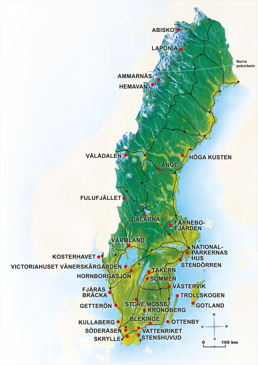
Places to visit
Öland
Öland, the long island in the southern Baltic Sea, has everything the visitor needs to ensure a steady stream of new encounters with birds.
The whole island of Öland could justifiably be described as a single fantastic place for birding, one big birding location, with migrating birds the year around and with a unique and spectacular environment.
Here we will describe 20 birding locations that together well covers most of the richness that characterizes Öland bird fauna.
The selected birding locations have all in common, that they are easy to find, to park at and can handle high visitor pressure. Some of the sites are bird sanctuaries with restricted access during parts of the year, however, the County Administrative Board of Kalmar has arranged so that there are marked trails and areas where it is possible to be the year around.
- visitoland.com
Öland
Known in Latin as Oelandia, and sometimes written Øland in other Scandinavian languages, and Oland internationally) is the second largest Swedish island and the smallest of the traditional provinces of Sweden. Öland has an area of 1,342 square kilometres and is located in the Baltic Sea just off the coast of Småland.
The island has 26,000 inhabitants. It is separated from the mainland by the Kalmar Strait and connected to it by the 6-kilometre Öland Bridge, which opened on 30 September 1972.
From Wikipedia, the free encyclopedia
I will visit the below areas, 20 areas for birding on Öland. I got the list from the web page Visit Öland - The top 20 birding sites on Öland with maps and information:
• 01. Ölands Norra Udde (The northern head of Öland)
• 02. The Bay of Böda and the Böda Harbour
• 03. Horns “Kungsgård” Nature Reserve and Hornsjön / Lake Horn
• 04. Högby hamn / Högby Harbour
• 05. Södviken - Naturreservat Södviks Sjömarker
• 06. Petgärde träsk (Swamp)
• 07. Kapelludden
• 08. Halltorps Hage
• 09. Stora Rör
• 10. Södra Utmossen at Lenstad village
• 11. Beijershamn
• 12. Möckelmossen
• 13. Stenåsabadet and Stora ören
• 14. Sockerbruksområdet in Mörbylånga
• 15. Penåsa
• 16. Görans dämme
• 17. Västerstadsviken (bay)
• 18. Seby läge and Gammalsbyören
• 19. Gräsgårds hamn (harbour)
• 20. Ottenby area - Ölands Södra Udde (The southern head of Öland)
• * I have added Naturum - Trollskogen as a MUST visit birding spot
There are excellent maps over the different sites on Visit Öland´s web page with trails, bird towers etc.
01. Ölands Norra Udde (The northern head of Öland)
To reach Ölands Norra Udde and the lighthouse Långe Erik you just have to drive along road #136 towards north until you reach a sign and you turn left driving about 2 km until the dead end, a parking area.
Park your car and from there you walk to the lighthouse, crossing a bridge. There is a trail around the island. If you walk back along the road from the parking, about 100 meters and there is an area where they use to see eagles.

How to find Ölands Norra Udde and the lighthouse Långe Erik

Approaching Ölands Norra Udde and we see the lighthouse Långe Erik

End of the road and we can see the parking

End of the road and we can see the walk path to the lighthouse

Walk from the parking to the lighthouse Långe Erik

Walk from the parking to the lighthouse Långe Erik

The lighthouse and dwellings from the jetty
There is a small jetty and there are some waders on the beach and there are quite a few birds in the bushes. There is a garden around the lighthouse keepers dwellings and there are quite a few birds stopping to have a rest on their way towards north.
The trail around the island goes along the rocky beach and there are sea birds that gets scared and take off before you can get any pictures.
My eBird checklist from Ölands norra udde - 13 May 2019, click HERE
My eBird checklist from Ölands norra udde - 14 May 2019, click HERE
02. The Bay of Böda and the Böda Harbour
Böda HarbourvBöda is located just south of Böda. There are signs when you drive along road #136 so it is quite easy to find. Drive down toward the sea and you pass a camping on the right hand side and then you have a huge parking area when you reach the sea front.

To find Böda Harbour
Parking the car and I stepped out, but I was soon back in the car again. It was cold, windy and raining. So I stayed in the car and I drove around the harbour looking for birds. As soon as I stepped out of the car the birds took off. So it was actually good to be in the car working as a hide.
There is also a smoked fish place and I bought smoked salmon that was very good and I had a snack/ lunch.

The beach south of Böda Harbour

The beach north of Böda Harbour
You can come quite close to the beach with the car. Even though it was very cold, windy and rainy I tried to get out of the car. Open the door was enough to scare away the birds. So if you want pictures you should try to use your car as a hide. On a sunny day it would be very nice to get out for a walk around.
In the harbour you can find seabirds hiding between the small boats and the rocks.

North part of the harbour and plenty birds driving out on the breakwater

Böda Harbour

Böda Harbour
My eBird checklist from The Bay of Böda and the Böda Harbour - 13 May 2019, click HERE
My eBird checklist from The Bay of Böda and the Böda Harbour - 14 May 2019, click HERE
My eBird checklist from The Bay of Böda and the Böda Harbour - 16 May 2019, click HERE
03. Horns “Kungsgård” Nature Reserve and Hornsjön / Lake Horn
You will pass a sign saying Horns Kungsgård Nature Reserve and from there it is a little confusing. I stopped at two parking places. But not much information tha I could see. I drove up to a information board and it looked to be 1 or 2 kilometres to walk. No problem. 15 minutes or so.
But I don´t want to leave my car far behind in case of heavy rain. I bought a new camera before coming here, 3000 US Dollars and I don´t want the camera to end up full of water like my MK III
So I left and if the weather turns good before leaving Öland I will come back here again to check it out.

Horns Kungsgård

04. Högby hamn / Högby Harbour
As you can see on the map below, drive along road #136 from south to north and you pass all the birding hot spots. Leave road #136 and you will end up on a small road going down to the beach north of Högby hamn / Högby Harbour . You will find a large parking area.
You will have to walk from the parking area and there is a board walk down to the beach. There is a dust road going south from the parking, but not allowed to drive the car so you will have to walk.

How to find Högby hamn / Högby Harbour

Reaching the parking area at the beach

Reaching the parking area at the beach

The parking area

Board walk down to the beach
Only walking allowed
Walking south on the dust road and you walk along the beach on your left hand side and on your right hand side you have old tool sheds for fishing equipment etc. You have waders and seabirds on the beach and in the water and in the small fishing harbour.

Walking towards the harbour

The beach

Walking along the old tool sheds for fishing equipment etc.

Approaching the fishing harbour

Approaching the fishing harbour
Walking past the harbour and keep close to the tool sheds and coming to the end make sure to walk so you are covered by the bushes when approaching the beach south of Högby hamn / Högby Harbour . If you can stay out of sight you have a very good chance to come close to the birds on the beach.
Walking along the beach and you have sea birds and waders along the beach. On the fields you can see some ponds and when I was there it was at least 1000 Barnacle Gooses around the ponds.

The beach south of the fishing harbour

The fields with the ponds
Högby hamn / Högby Harbour is a very nice place, and it is well worth a visit, just to walk around enjoying the scenery even if you´re not in to bird watching.
My eBird checklist from Högby hamn / Högby Harbour - 13 May 2019, click HERE
My eBird checklist from Högby hamn / Högby Harbour - 15 May 2019, click HERE
05. Södviken - Naturreservat Södviks Sjömarker
Again, you are driving along road #136 and when you reach the village Södvik it is time to leave road #136. There are signs “Naturreservat Södviks Sjömarker” BUT after leaving road #136 there is only one more sign saying “Naturreservat Södviks Sjömarker” when you reach Gamla Vägen (Gamla Road)
From there the signs are saying “NATURRESERVAT” and you leave Gamla Vägen and you reach a fork, keep left and drive along a small road until the end where there is a parking.

How to find Södviken - Naturreservat Södviks Sjömarker

© Lantmäteriverket, Ur Geografiska Sverigedata, översiktskartan Dnr. 106-2004/188”
Map from https://visitoland.com

Signs to Södviken - Naturreservat Södviks Sjömarker

Signs to Södviken - Naturreservat Södviks Sjömarker

After taking off road #136 the sign say NATURRESERVAT

Keep left in the fork and follow the NATURRESERVAT sign

Drive along a small road

Drive along a small road

Reach the end of the road and there is a parking

We can see Södviken - Naturreservat Södviks Sjömarker from the parking
Park your car at the parking and from there you will have to walk a few hundred meters. Just climb over the fence on a wooden ladder and you will walk across the meadow towards the sea. There is a bird watching platform, great if you want to check off birds from a list. But a pretty pointless place if you want to take bird pictures.
My eBird checklist from Södviken - Naturreservat Södviks Sjömarker, click HERE
06. Petgärde träsk (Swamp)
This place was not so easy to find. Driving along the road going from south to north on the east side of Öland. And as everything else here on Öland, the place is not far away from road #136.

How to find the Petgärde träsk

You have to walk the last few hundred meters

© Lantmäteriverket, Ur Geografiska Sverigedata, översiktskartan Dnr. 106-2004/188”
Map from https://visitoland.com
Driving along the road and there is a parking sign and when you reach the parking lot, no indication that there is a nature reserve here. Just a small parking next to the road. There is a sign saying Petgärde träsk pointing at the parking. I missed this and I had to make a U-turn.
I checked the small signs at the parking, and yes, it was a nature reserve.

A parking sign next to the road - SLOW DOWN!

A parking sign next to the road - SLOW DOWN!

There is a sign at the parking

Some information about the nature reserve, and a trek trail sign
I only knew about the nature reserve after having studying the information board. There is also a sign saying “STRÖVSTIG” and that means TREK TRAIL.
You will walk on the trail, about 25 meters and you will have to climb a wood ladder. Walk along the trail or the field until you come to another wood ladder. Walk across a stream and after about 100 meters you will have to get over yet another wood ladder to get over the fence.

Follow the trail

Follow the trail

You can see the swamp from the trail

First ladder to cross the fence
If you come to Öland you will climb a lot of these ladders as you walk across meadows and fields with cattle etc. to reach the birding areas. It was dry so I chose to walk on the field next to the trail until the next wooden ladder to get across the fence.

I chose the field instead of the trail
Cross the stream and you walk along the forest until you reach the third and last ladder. From there you walk the trail to the bird watching tower. I spotted warblers and I was very happy to see the Eurasian penduline tit.
I spotted 3 White-tailed Eagle from the bird-watching tower. You have a good sight over the swamp from the tower. Too far away for any pictures, but excellent ig you´re here to cross of birds from a list.
My eBird checklist from Petgärde träsk (Swamp) - 14 May 2019, click HERE
My eBird checklist from Petgärde träsk (Swamp) - 15 May 2019, click HERE
07. Kapelludden
Kapelludden us a very beautiful area just south of Kapelludden Lighthouse and a church ruin. To find the place you need to find the village Bredsätra. Located on the road on the east side of Öland going from Otterby to the north of Öland.

How to find Kapelludden

Kapelludden

Road sign pointing to Kapelludden at Bredsätra

Driving towards Kapelludden on the small road

You see the lighthouse from the road

The church ruin

Park on the left side of the road
Keep an eye out for Eurasian Curlew and the Black-tailed Godwit driving on the small road towards Kapelludden. They are nesting along the road. Park at the house, walking only to the harbour. You can drive to the light house if you want to look for birds at that area.
Walk down to the harbour, it is a very beautiful area and fell worth a visit even if you don´t look for birds. Walk down to the breakwater and you pass beautiful small fishing huts. Look to the left and you see the lighthouse and the church ruin.
The area south of Kapelludden was full of Barnacle gooses, thousands of them when I visited.

No traffic allowed

Walking along the fishing huts towards the breakwater

Walking along the fishing huts towards the breakwater

We can see the breakwater

Kapelludden

Kapelludden harbour
Kapelludden harbour

We can see the lighthouse from the breakwater
To explore the area around the lighthouse you have to park at the lighthouse and walk down to the beach from there. A beautiful area and you can see seabirds and waders along with small normal birds as well.

Kapelluddens Lighthouse


My eBird checklist from Kapelludden, click HERE
08. Halltorps Hage
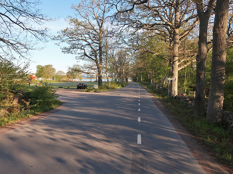
Driving along road #136 and you turn off at the sign for Halltorps hage and continue for just over a kilometre. You drive with the forest on your right hand side. There is free parking for the nature reserve on the left hand side when you reach the parking area. Park on the top, if you continue a little furthet towards the sea it is parking for tha camping area.

How to find Halltorps Hage

© Lantmäteriverket, Ur Geografiska Sverigedata, översiktskartan Dnr. 106-2004/188”
Map from https://visitoland.com
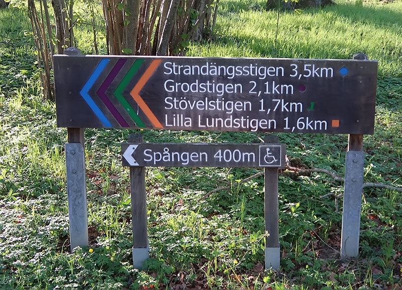
Park the car and walk back for about 50 meters and there is a gate through the fence. There is colour coded trails and they are easy to follow. One of the trails, the “SPÅNGEN” (Boardwalk) and it is a 400m long trail which is suitable for disabled people.And you can walk quietly sneaking up on the birds.
The best thing with the boardwalk is that you can look for birds at the same time as you walk. In rough terrain you have to concentrate on where you putting your feet.
Leaving the car at the parking walking to the gate

Gate to Halltorps Hage
Colour coded trails

One of the trails, a board walk so you can come here in a wheel chair

Easy to follow the colour coded trails
Leaving the board walk and I decide to follow the orange coloured trail. Take you through the forest and you walk back along to coast. The forest is full of birds and my eBird checklist would have been very impressive if I could have identified the bird.
And there were quite a few information board with information and interesting facts.

A beautiful area

A beautiful area

A beautiful area

I follow Grodstigen (Frog trail)
Coming out of the forest (If you follow the orange coloured trail) and you will see waders and sea birds along the coast. I spotted several Grey Herons. Halltorps Hage is a recommended place and I will come back next time on Öland.
My eBird checklist from Halltorps Hage, click HERE
09. Stora Rör
Stora Rör, not far from the bride to the mainland. Coming from the mainland driving along road #136 and leave road #136 as directed by the signs to Stora Rör. Drive down to the marina and park your car there. Takes 3 minutes to walk to the bird watching platform / hut overlooking the see.

To find Stora Rör

Plenty parking space in the marina
The coast north of Stora Rör

Bird watching platform / hut
I will not bother to came back to Stora Rör. This is a place where the watch passing birds flying by over the water, and I quote https://visitoland.com:
Stora Rör’s harbour area is the premier site of western Öland for sea bird migration and thus is a place to visit mainly during the spring and autumn.
In the harbor area there are many parking lots and at the waterfront is a newly built platform with a roof to seek shelter under. Since the Kalmar strait is narrowest here, only three kilometres, and even though the sea birds migration path goes past in a comfortable binoculars distance, spotting scopes are recommended for this type of birding.
Of course, there was birds but nothing special. This is not a place for bird photographers. I have no doubt that it is excellent for bird waters during the migration. But for taking pictures, well, there are better places, much better places on Öland.
My eBird checklist from Stora Rör, click HERE
10. Södra Utmossen at Lenstad village
Södra Utmossen is a wetland / swamp 15 minutes’ walk from Lenstad village. It is no problem to find Lenstad village using the map on Visit Öland´s web page. Park the car and then? To find Södra Utmossen was not so easy. I walked around and I found a sign saying “Walk Trail”
I followed the sign and then there was no directions. I asked two girls with horses and they showed me the way. You need to pass through two gates that you need to close. There are horses and if you don´t close the gate the horses will run away.

Easy to find

Parking at Lenstad village

Sign saying “Walk Trail”

Follow the gravel road

Last gate to be closed

Bird watching platform

Södra Utmossen
It is a beautiful area but the birds was too far away to get any good pictures. And I actually spotted more interesting birds going to and from Södra Utmossen.
Takes about 10 minutes to walk from the parking to the bird watching platform and then about 3 minutes more of walking to reach Södra Utmossen. The platform is good for bird watching, spot the bird in the tube and thick the list. But for photographers it is another story, you will have to sneak down to the swamp in order to have a chance to come close to the birds.
My eBird checklist from Södra Utmossen at Lenstad village, click HERE
11. Beijershamn
Driving south from Färjestaden and you have to turn right after about 10 minutes. There are signs so it is easy to find. Drive down the road until you reach the sea and you turn right again.
Drive along the gravel road until you reach the parking area. There are some tables for picnic at the parking area. Then you have a walk path along the coast and you will walk back through the forest coming back to the parking area.

How to find Beijershamn

Parking area

Pass the gate to get to the trail

Board walk to the first bird watching tower

Walking along the beach

Board walk over the swamp

Walk back through the forest

Walk back through the forest

Walk back through the forest
There are two bird watching towers at Beijershamn, the first one at the parking and the second tower when you reach the forest. The beach area is mostly for bird watchers as the birds are too far away for any pictures. But the walk through the forest is very nice and you come close to the birds (if you are lucky)
I left the car behind and I walked through the gate, and it is important to close the gate as there are farm animals on the fields and we don´t want them to escape. There is a board walk from the gate to the gravel walk path along the coast line. You reach the bird watching tower first thing coming to the end of the board walk.
When you reach the end of the gravel trail you get on another board walk crossing the swamp and when you are across there are another bird watching tower and from there it is a walk path through the forest back to the parking.
My eBird checklist from Beijershamn - 12 May 2019, click HERE
My eBird checklist from Beijershamn - 16 May 2019, click HERE
My eBird checklist from Beijershamn - 17 May 2019, click HERE
12. Möckelmossen
Möckelmossen is not hard to find. Driving on road #136 and you only need to turn once. There are signs when to leave the road. Leaving road #136 and you drive for a few minutes and you reach a parking area with a toilet. This is it and you cannot miss it.
Park the car and before walking to Möckelmossen you can cross the road. There is a small pond and I spotted the Common Ringed Plover and the Common Linnet.

Finding Möckelmossen

Follow the sign to Möckelmossen

Parking and toilet

Information and benches

Walking towards Möckelmossen

Approaching Möckelmossen

Approaching Möckelmossen
It is about 1 km to walk from the parking to Möckelmossen and, at least when I was walking there, there wasn´t any birds to see. Möckelmossen, I spotted a Whooper Swan and a few Greylag Gooses. I heard that there had been a huge group of Black-headed Gulls last year and they had scared away the birds.
My eBird checklist from Möckelmossen, click HERE
13. Stenåsabadet and Stora ören
If you come here to look at the Long-eared Owl, PLEASE!!!!! PARK AT THE GUEST PARKING!!! IT IS A VERY FRIENDLY OWNER AND HE REALLY APPRECIATE VISITORS TO COME LOOK AT THE OWL! SO PLEASE!!!!! PARK AT THE GUEST PARKING!!!
Some respect for the owner and the guests at the camping. I will not say where the owl is, have been nesting there for 5 years so it is there to stay. But ask the owner and he will be more than happy to show you.

To find Stenåsabadet

Stenåsabadet
My eBird checklist from Stenåsabadet - 14 May 2019, click HERE
My eBird checklist from Stenåsabadet - 16 May 2019 - Early morning, click HERE
My eBird checklist from Stenåsabadet - 16 May 2019 - Mid day, click HERE
My eBird checklist from Stenåsabadet - 17 May 2019, click HERE
14. Sugar Mill Area in Mörbylånga
It really looks like a ghostly industrial landscape and I had to drive around to make sur eit was the right place. There was two birds of Prey over the pond north of the area and I realised that this was the place. I could see the ponds when I came up on the west side. I parked the car and I could see the bird watching tower.

How to find the Sugar Mill Area in Mörbylånga

Sugar Mill Area in Mörbylånga

For sure, don´t look like a birding area
I quote https://visitoland.com:
In the early 1990s, the sugar mill in Mörbylånga closed down. Remaining was a ghostly industrial landscape. Northwest is the Mörbylånga sugar mill park that now is a recreation area with a rich birdlife.
During the sugar mill era the area of networked embanked ponds was used for washing of sugar beet.
Today, the area is developed with walking trails and an observation tower, from which one can see ducks, moorhens and grebes.
Walking to the bird watching tower between the ponds. Walk ways between the bonds and you walk above reeds and vegetation. It was really too far away and too much vegetation for any close up pictures of any birds.

We see the bird watching tower from the parking

Reeds at the parking

Bird watching tower

Walk paths between the ponds

Walk paths between the ponds
Walk paths between the ponds

Looking out over the east side pond


Not easy to see the birds behind the reed


Picnic area

My eBird checklist from Sugar Mill Area in Mörbylånga, click HERE
15. Penåsa
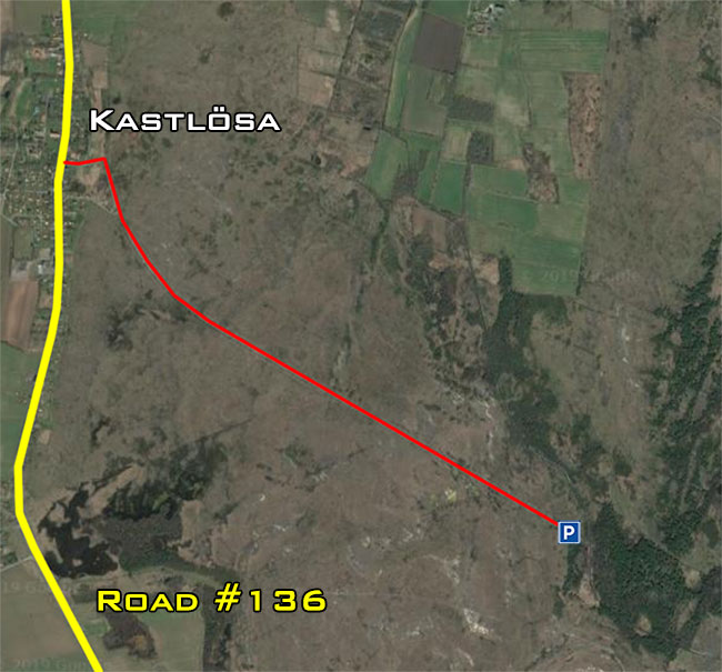
Driving along road #136 and you turn off the road at Kastlösa. Drive along the small road through the “ALVAR”for about 2km. Drive to the dead end and you will find a parking area. From there you will have to walk. Drive slowly on the road as you will “experience” cattle on the road and they might come to say hello to you.
Alvar
Öland – Stora Alvaret – largest alvar extent in Europe
An alvar is a biological environment based on a limestone plain with thin or no soil and, as a result, sparse grassland vegetation. Often flooded in the spring, and affected by drought in midsummer, alvars support a distinctive group of prairie-like plants.
Most alvars occur either in northern Europe or around the Great Lakes in North America. This stressed habitat supports a community of rare plants and animals, including species more commonly found on prairie grasslands. Lichen and mosses are common species. Trees and bushes are absent or severely stunted.
The primary cause of alvars is the shallow exposed bedrock. Flooding and drought, as noted, add to the stress of the site and prevent many species from growing. Disturbance may also play a role. In Europe, grazing is frequent, while in North America, there is some evidence that fire may also prevent encroachment by forest. The habitat also has strong competition gradients, with better competitors occupying the deeper soil and excluding other species to less productive locations.
From Wikipedia, the free encyclopedia
To find Penåsa

Penåsa

Driving towards the parking on the small road

Driving towards the parking on the small road


Approaching the end of the road

The parking area

Mörbylångaleden / Mörbylånga Trail
Mörbylångaleden
Mörbylångaleden is over 83 km long footpath passing through the unique natural and cultural environments from Träffpunkt Öland at the bridgehead in Färjestaden and Ottenby hostels Näsby.
The trail is divided into five stages and is marked with red wooden arrows. Along the trail, there are rest areas with shelters, toilets of simple standard, fireplaces with information about the Öland's nature, culture and history.
• Stage 1: Öland Tourist Office - Station Linnaeus, Skogsby. Distance: 18 km
• Stage 2: Station Linnaeus, Skogsby - Mörbylånga square. Distance: 18 km
• Stage 3: Mörbylånga squares - Kastlösa. Distance: 13.5 km
• Stage 4: Kastlösa - Gammalsby. Distance: 22 km
• Stage 5: Gammalsby - Ottenby (hostel) Distance: 12 km
Habitats
The trail winds through a mosaic of Öland landscape's various habitats, including the species-rich Mittlandsskogen, considered to be Northern Europe's largest contiguous deciduous forest area south of the mountain chain. The forest has largely arisen on old pasture and hay meadows which were used since the Iron Age. Even today you can see the small clearings interspersed with fields, meadows and wetlands. The trail leads to a large part of the Great Alvar and then follows the old railway embankment.
Accessible subsection
Hiking with wheelchair is possible Mörbylångaleden between Penåsa and Skärlöv. This trail follows an old railway embankment, and the substrate consists of a hard dirt road, in the middle grass. Embankment surrounded by Penåsabäcken and the Great Alvar.
To get to Penåsa, drive to Kastlösa church and cross the road 136 east toward Alvar. Parking is available for 3 km. In the car park there is a disabled toilet and the rest area is easily-accessible seating and fireplaces.
You have to walk from the parking area and walking down the embankment and you will soon have a rest area on your right hand. This is the remains of the old Penåsa train station. You will find picnic tables and restroom. There is even an air pump for your bike. And from the site there is a trail through the forest that will take you to

Mörbylångaleden / Mörbylånga Trail

Walking down the embankment

Penåsa rest area

Penåsa rest area

Trail in to the forest from the rest area
There were a lot of birds in the forest following the small trail through the forest. You walk through a beautiful forest and you come out at a small walk bridge crossing a small stream. Crossing the bridge and you come to an old ruin village. The bridge looked very flimsy and I didn´t care very much to try cross the bridge.
I would really have liked to see the village remains. The stream, it was like a gorge, 1 to 1 and a half meter deep. And the gorge was for long as I could see in both directions. For the more adventurous bird watchers it would be no problem to cross.

Walking back to the parking on the embankment
A very nice area and I will be back next time on Öland. Maybe they have done some maintenance on the walk bridge by then. When I walked back to the car it was around 8 thirty when I walked back to the car and people start to use the embankment for walking their dogs.
My eBird checklist from Penåsa, click HERE
16. Görans dämme
Görans dämme is located just inside the coast at Hulterstads beach and is signposted from the main road in the village. On the east side South - north main road you turn towards east when passing through the village “Hulterstad”
Very easy to miss the small dust road. Only a small sign and you drive between two houses so you might think you enter in to someones garden.

To find Görans dämme

Easy to miss the sign

Follow the dust road to the parking

Keep your eyes out for birds along the road

Follow the signs to the parking

Reaching the parking - From here you have to walk
I never visited Görans dämme. I was at the parking but I turned around because of the bad weather. Glom and grey for long as I could see and Görans dämme looked to be a good distance away from the parking area. And as I have a new camera I don´t want to be too far away from the car with my camera if it start to rain.
17. Västerstadsviken (bay)
Coming from the north and you leave road #136 turning right at Bjärby continuing south until you see the sign. Turn right and drive down to the parking area on the gravel road. There is a parking area at the end of the road and you have to walk from there.
Takes 5 to 10 minutes to reach the bird watching platform and, well, I didn´t spent many minutes at the bird watching in Västerstadsviken. A place just for binoculars and the birds was too far away for any pictures and I knew that I would never come back.

How to find Västerstadsviken

The parking area

Walk path to the bird watching platform

The bird watching platform
My eBird checklist from Västerstadsviken (bay), click HERE
18. Seby läge and Gammalsbyören
Leave the road getting on the small road down to the parking area at Sebybadet. Drive slowly and keep an eye on the meadows and the stone walls along the road. Common Linnets like to sit on the wall and you have many birds on the meadows.
Reaching the parking and you walk along the beach looking for waders and you can count on company as there are cows chasing you to say hello. I left when I discovered that the cows where bulls, but they were very kind and they just wanted to say hello.

How to find Sebybadet

There are signs when to turn off the road

The small road down to Seby läge

Seby läge

You will get new friends at Sebybadet
But it is annoying to have the cattle following you, sniffing your behind, biting your belt etc. Not so easy to sneak up on the birds to take pictures. Walking down south on the pastureland and you will soon reach the bird protection area. But you can drive down to site #19, Gräsgårds hamn a 5 minutes´ drive down south to get around the bird protection area.
My eBird checklist from Seby läge and Gammalsbyören, click HERE
19. Gräsgårds hamn (harbour)
Leave the road turning left if you are coming from the north. Drive down towards the harbour and keep your eyes on the meadows along the road as there are many birds. Coming down to the harbour you will have to walk as cars are not allowed.
How to find Gräsgårds hamn
My eBird checklist from Gräsgårds hamn (harbour), click HERE
20. Ottenby area - Ölands Södra Udde
Ottenby Nature reserve is covering the south tip of Öland. And it is very easy to find, just drive soth for as long as you can and you reach the gate. And there are signs OTTENBY all the way from the north of Öland. Road #136 goes along the west coast of Öland, from Länge Erik lighthouse at the north tip all the way down to the the entrance to Långe Jan lighthouse and Ottenby Nature Reserve at the southern tip of Öland.
Road #136 pase the gate to Långe Jan lighthouse and Ottenby Nature Reserve. Outside the gate the road turns in to a road with no number and it goes all the way up north again on the eastern side of Öland.
Information and map in English from Länsstyrelsen Kalmar Län, click HERE for pdf file. There are 4 trekking trails:
• Kyrkhamnsleden
• Västra Markslingan
• Skogsuddeslingan
• Norra lundleden
Leaving road driving down towards the gate and you can either just proceed through the gate and drive along the road towards the light house in the south, 5 minutes drive or so. At the lighthouse you have a bird station and Naturum.
You can also turn right in front of the gate. But then you just have to open a boom across the road. Pass the boom stop and close the boom. Drive about 200 meters and there is a parking area. From there you walk down to the forest a few minutes´ away from the parking.


Reaching the gate to Ottenby Nature reserve
Drive slowly along the narrow road. and keep an eye out for birds along the road. About half way to the lighthouse there is a parking area close to many of the walking trails in the area. After having passed the parking area there are many birds along the road. Must have been thousands of gulls, terns and gooses etc.

Driving towards the lighthouse

Driving towards the lighthouse

Driving towards the lighthouse

Driving towards the lighthouse

Plenty parking space at the lighthouse
There are many parking places at the lighthouse. There is a bird station where they ring millions of birds. Walk hundred meters and you reach the lighthouse and Naturum.
There is a restaurant at Naturum with an outdoor section. And there is a small wetland area and you can see a lot of birds there. There is also a wall that you can use as a hide. BUT!!! There is a sign that there are vipers living in the stone wall, but I guess it is just because they don´t want people to lean on the wall.

Walk to the bird hide, but don´t lean on the wall


Naturum on the right hand side
My eBird checklist from Ottenby area - 12 May 2019, click HERE
My eBird checklist from Ottenby area - 15 May 2019, click HERE
My eBird checklist from Ottenby area - 16 May 2019, click HERE
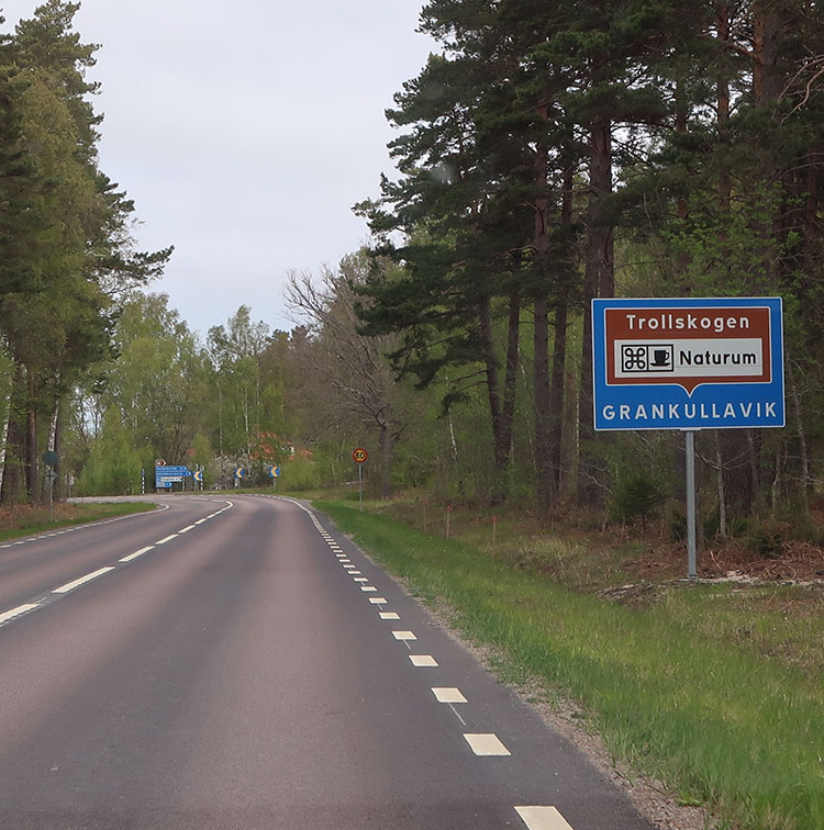
Naturum Trollskogen - Not on Visit Öland´s web page
Following road #136 from the south and you will see the sign and you only have to turn right two times from road #136 to reach Naturum - Trollskogen

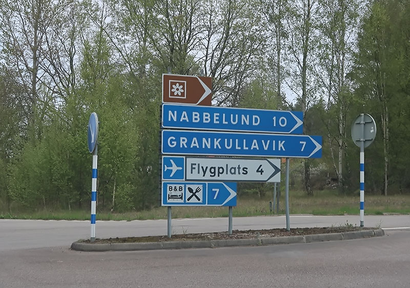
How to find Naturum - Trollskogen

How to find Naturum - Trollskogen
You see the signs following road #136

Leave road #136
Leave road #136

Grankullavik and you leave to road, 2 km to go

After leaving the road at Grankullavik you can see the lighthouse
Långe Erik on Ölands Norra Udde on your left hand side
Långe Erik on Ölands Norra Udde on your left hand side

Drive through the beautiful forest

Drive through the beautiful forest

Drive through the beautiful forest

Drive through the beautiful forest

Reaching Naturum - Trollskogen

Reaching Naturum - Trollskogen
Leave road #136 and when you come to Grankullavik you turn right at the sign. From here you have 2 kilometre to go to Naturum - Trollskogen and you drive along a beautiful stretch of road. First few hundred meters and you can watch the lighthouse Långe Erik on Ölands Norra Udde on your left hand side.
There is a huge parking area and a Naturum Visitor Center with a very helpful staff. Walking trails marked with colours and there is great maps available.

Beautiful trails in the forest and it was a pleasure to walk the forest. But to get bird pictures, you will have to leave the trail. I left the trail, 20 to 30 meters off the track and I sat down on a dead tree trunk. Sit down for 10 to 15 minutes´ and I was soon surrounded by birds. Due to the weather I didn´t went in to the forest on my first visit.
But at my second visit I managed to see two of the very beautiful Common Firecrest, the very reason for me to come to Naturum - Trollskogen.

Gate to the forest

Easy to follow directions

Beautiful trails
My eBird checklist from Naturum Trollskogen - 16 May 2019, click HERE
Bird checklist
I never use any bird lists, but since I try to make it in to Cloudbirders . A very helpful site when planning your birding trips. But they ask for a bird checklist, and if I use their service, of course I want to contribute as well. My two first bird watching trip reports was rejected by Cloudbirders.
So I started to take ideas from the reports I found on Cloudbirders. So I have started to use bird lists, eBird generate one for me and I can post it on Cloudbirders. I will post my birds on eBird and on my different “BIRDS THAT I HAVE OBSERVED” pages.
Check lists can come in handy to find out the local name of the bird etc. And Avibase have a list with pictures and sounds, excellent!
So I will post bird checklists here and if my Guides provide me with checklists I will also post them here.
Öland bird checklist from Avibase, click HERE
Avibase is providing you with bird checklists from all over the world. And I´m impressed by their web page. Select country and area and you get the bird checklist. Like the PDF files I got from Avibase on the links above. You also get the checklist with pictures and sounds.
The best part is that you get the local names of the birds and the online checklist gives the names in English plus the language you have selected. But it seems like the PDF cannot handle some alphabet.
For example the Japanese language so it is blank in the PDF checklist. But it worked excellent with Swedish. But you get them in the local language on the online version.
Bird list
I only listed birds I have got on picture before I started with eBird in November 2019. Now I record all the birds that I can identify. Before that see the DAY TO DAY reports and my lists of observed birds in different countries.
And you can visit my list of “ Birds I have seen in Sweden ”
My eBird checklists can be found HERE
Itinerary
Click on the links below for daily bird watching results:
11 May 2019: Drive to Öland - Bird watching on Öland
12 May 2019: Öland – Bird watching
13 May 2019: Öland – Bird watching
14 May 2019: Öland – Bird watching
15 May 2019: Öland – Bird watching
16 May 2019: Öland – Bird watching
17 May 2019: Öland – Bird watching before driving to Skåne
Next adventure: Bird Watching Trip Report - Äspet, Skåne


You are visitor no.
To www.aladdin.st since December 2005
Visitors from different countries since 26th of September 2011